One Platform. Every Layer You Need: Unlocking the Power of FusionMap’s Premium Layers
Feature
- 12 Sep, 2025
- 2.1k Views
- 0 Comment
In today’s fast-paced field environments, the ability to interact with and understand 3D geospatial data isn’t just a nice-to-have; it’s a competitive advantage. Whether you’re analyzing terrain shifts, inspecting assets, or comparing before-and-after site conditions, you need a tool that combines LiDAR data visualization with actionable insights.
FusionMap’s LiDAR Viewer and Hybrid Viewer are designed to help teams visualize, measure, and analyze 3D environments directly from the web; no plugins, no third-party tools, and no GIS degree required!
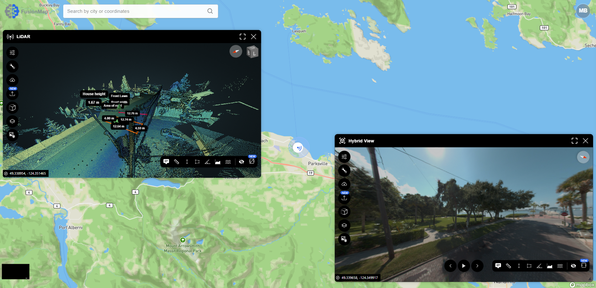
👁️ A Modern, Web-Based LiDAR Viewer with Measurement Tools
Many professionals ask: “What’s the best LiDAR viewer for infrastructure work?”
The answer depends on speed, accessibility, and what you can do with the data, not just how it looks. FusionMap checks every box:
- Web-based LiDAR visualization – no heavy software installs
- Point cloud measurement tools – measure distance, height, slope, and area in 3D
- Split-screen LiDAR + imagery comparison for change detection
- Custom LAS file export for focused analysis or reporting
- Intuitive controls for smooth navigation of dense 3D data
This makes it an ideal choice for teams in transportation, mining, utilities, and emergency response – all of whom rely on LiDAR to inform critical decisions.
🛰️ Visualize and Compare LiDAR & Imagery Side by Side
Looking for a way to compare LiDAR and imagery in one interface?
FusionMap’s Hybrid Viewer lets you view panoramic imagery alongside synchronized LiDAR point clouds. This enables teams to:
- Validate conditions across terrain or infrastructure
- Spot defects or changes not visible in one data type alone
- Quickly review inspections with geotagged images and spatial overlays
If your team handles geospatial change detection, before-and-after terrain analysis, or asset condition monitoring, this feature makes FusionMap a standout option.
🧰 Turn Your LiDAR Scans Into Actionable Workflows
With FusionMap, your 3D data becomes more than a static visual; it becomes a living layer of insight. Here’s how teams are using it:
- Transportation Agencies are identifying road defects using geotagged imagery and measuring degradation over time
- Mining Operators are tracking haul roads and slope stability directly from the point cloud
- Inspectors are annotating assets, taking measurements, and exporting subsets; all within a unified geospatial platform
- Engineers are analyzing infrastructure with digital twins built from panoramic + LiDAR data
🔍 Why FusionMap Is the Best 3D Mapping Platform for Your Team
If you’re looking for the best 3D mapping software or a tool that can handle LiDAR inspection workflows at scale, FusionMap delivers:
- ✅ A clean, browser-based interface
- ✅ Integrated measurement and annotation tools
- ✅ High-performance point cloud rendering
- ✅ Scalable LAS file handling via Fusion Cloud
- ✅ No-code dashboarding with FusionLens
- ✅ Full field-to-office sync via the iOS app
In short, FusionMap is a geospatial visualization tool built for real-world work.
✅ Ready to Explore Your LiDAR Data with More Clarity?
Your spatial data is only as powerful as your ability to understand it.
With FusionMap’s LiDAR and Hybrid Viewers, your team can make confident, data-driven decisions without the overhead of complicated GIS software or multiple tools.
Want to see how it works? Get in touch with our team today.